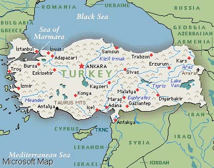
The lands of Turkey are located at a point where the three continents making up the old world, Asia, Africa and Europe are closest to each other, and straddle the point where Europe and Asia meet. Geographically, the country is located in the northern half of the hemisphere at a point that is about halfway between the equator and the north pole, at a latitude of 36 degrees N to 42 degrees N and a longitude of 26 degrees E to 45 degrees E. Turkey is roughly rectangular in shape and is 1,660 kilometers long and 550 kilometers wide.
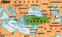
Turkey is an Eurasian Country |
Turkey has two European and six Asian countries for neighbors along its land borders.
The land border to the northeast with the Commonwealth of Independent States is 610 kilometers long; that with Iran, 454 kilometers long, and that with Iraq 331 kilometers long. In the south is the 877 kilometer-long border with Syria. Turkey's borders on the European continent consist of 212-kilometer frontier with Greece and a 269-kilometer border with Bulgaria.
Because of its geographical location the mainland of Anatolia has always found favor throughout history, and is the birthplace of many great civilizations. It has also been prominent as a center of commerce because of its land connections to three continents and the sea surrounding it on three sides.
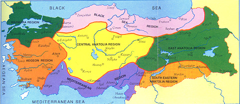
Turkey is generally divided into seven regions; the Black Sea region, the Marmara region, the Aegean, the Mediterranean, Central Anatolia, the East Anatolian and Southeast Anatolia regions.
Neighbors of Turkey |
The uneven north Anatolian terrain running along the Black Sea resembles a narrow but long belt. The land of this region is approximately one-sixth of Turkey's total land area.
The Marmara region covers the area encircling the Sea of Marmara and includes the entire European part of Turkey, as well as the northwest of the Anatolian plain. Whilst the region is the smallest of the regions of Turkey after the Southeast Anatolia region, it has the highest population density of all the regions.
|
Geographical Regions of Turkey |
The Aagean region extends from the Aegean coast to the inner parts of western Anatolia. There are significant differences between the coastal areas and those inland, in terms of both geographical features and economic and social aspects.
In the Mediterranean region, located in the south of Turkey, the western and central Taurus Mountains suddenly rise up behind coastline. The Amanos mountain range is also in the area.
The Central Anatolian region is exactly in the middle of Turkey and gives the appearance of being less mountainous compared with the other regions. The main peaks of the region are Karadag, Karacadag, Hasandag and Erciyes (3,917 metres).
The Eastern Anatolian Region is Turkey's largest and highest region. About three-fourths of it is at an altitude of 1,500-2,000 meters. Eastern Anatolia is composed of individual mountains as well as of whole mountain ranges, with vast plateaus and plains. There are numerous inactive volcanoes in the region, including Nemrut, Suphan, Tendurek and Turkey's highest peak, Mount Agri (Ararat), which is 5,165 meters high.
The Southeast Anatolia region is notable for the uniformity of its landscape, although the eastern part of the region is comparatively more uneven than its western areas.